
A series of powerful “atmospheric river” storms are set dump historic amounts of rainfall across parts of drought-stricken California and the Pacific Northwest from this weekend, forecasters warn.
Why it matters: A strong atmospheric river, packing large amounts of moisture, is predicted to whiplash Northern California from drought to flood.
A tweet previously embedded here has been deleted or was tweeted from an account that has been suspended or deleted.
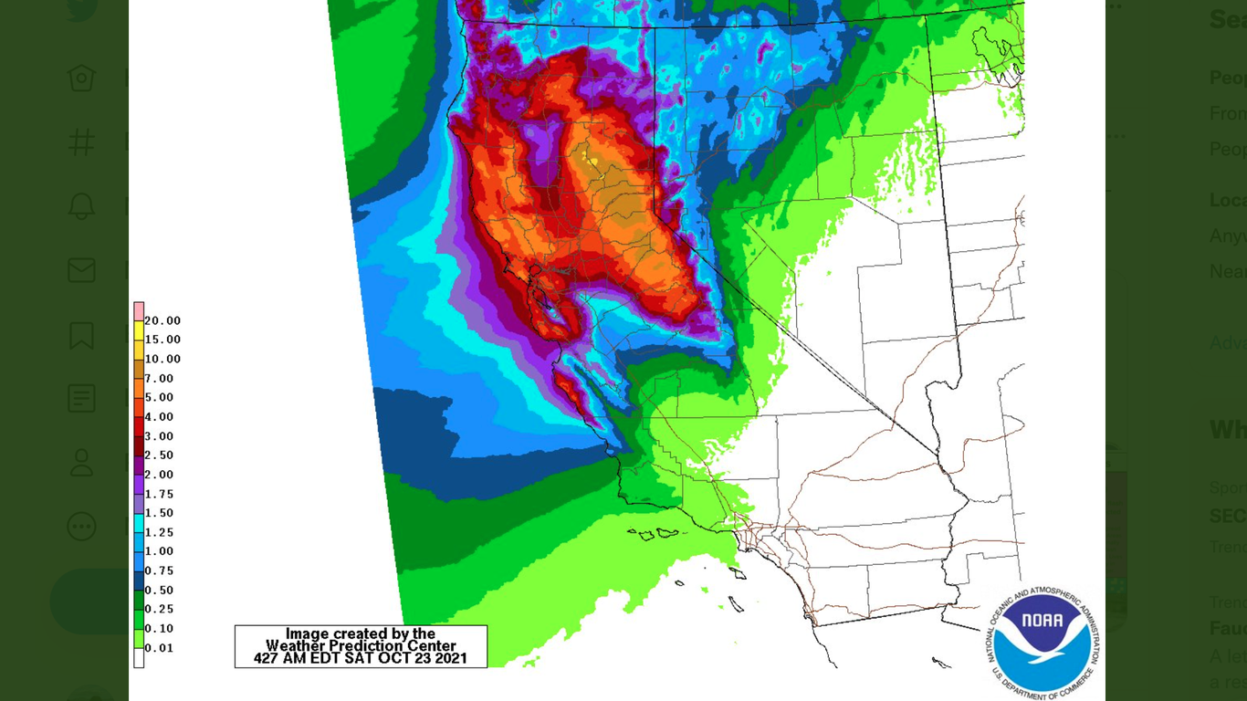
- It’s set to hit with historic intensity, dumping 8-10 inches of rain across the region Sunday — potentially triggering “life-threatening flash floods and mudslides, particularly over burn scar areas,” razed by recent wildfires, per the National Weather Service’s Weather Prediction Center.
Threat level: The storm is associated with a “bomb cyclone” off the Pacific Northwest, which was forecast to remain at sea.
- But it’s set to bring wind gusts of up to 60-70 mph and potentially hazardous swells along the coasts of northern California, Oregon, Washington and British Columbia.
- A bomb cyclone refers to a non-tropical storm whose pressure drops at least 24mb in 24 hrs. This one should more than double that rate.
What to watch: The atmospheric river was forecast to hit the San Francisco Bay area as a category 5 — the highest level on a scale based on strength and duration, per the Center for Western Weather and Water Extremes at Scripps Institution of Oceanography.
- It’s set to qualify at level 3 or 4 in other parts of Northern and Central California and elsewhere in the Pacific Northwest.
Meanwhile, the parade of storms could see two to four feet of snow in the Sierra Nevada region by Monday morning — where flooding was also a concern, particularly in burn scars, according to the NWS.
Of note: Sacramento, which has been experiencing its longest dry spell ever, after breaking a record set in 1880 earlier this month, faces “potentially historic” rainfall, the NWS noted.
- “The current 24hr rainfall forecast for tomorrow is 4.86in,” the agency tweeted, which would make it the second highest rainfall total on record. “Be prepared for flooding and plan on staying home tomorrow!”
Between the lines: That turnaround marks an example of the extremes that are known to buffet California, with precipitation going from “feast to famine” and back again — except the odds are stacked even further in favor of extremes now with climate change.
Yes, but: Not all of California was forecast to be hit by this rainfall, and fire season was set to continue in south of the state.
- The extreme rainfall won’t be enough to end the drought for most places, though it will help.
A tweet previously embedded here has been deleted or was tweeted from an account that has been suspended or deleted.
Editor’s note: This article has been updated to include the forecast for the Sierra Nevada, with more details on the likely affected burn scars and further context on atmospheric rivers.
A series of powerful “atmospheric river” storms are set dump historic amounts of rainfall across parts of drought-stricken California and the Pacific Northwest from this weekend, forecasters warn.Why it matters: A strong atmospheric river, packing large amounts of moisture, is predicted to whiplash Northern California from drought to flood.A tweet previously embedded here has been deleted or was tweeted from an account that has been suspended or deleted.It’s set to hit with historic intensity, dumping 8-10 inches of rain across the region Sunday — potentially triggering “life-threatening flash floods and mudslides, particularly over burn scar areas,” razed by recent wildfires, per the National Weather Service’s Weather Prediction Center. Threat level: The storm is associated with a “bomb cyclone” off the Pacific Northwest, which was forecast to remain at sea. But it’s set to bring wind gusts of up to 60-70 mph and potentially hazardous swells along the coasts of northern California, Oregon, Washington and British Columbia. A bomb cyclone refers to a non-tropical storm whose pressure drops at least 24mb in 24 hrs. This one should more than double that rate.What to watch: The atmospheric river was forecast to hit the San Francisco Bay area as a category 5 — the highest level on a scale based on strength and duration, per the Center for Western Weather and Water Extremes at Scripps Institution of Oceanography. It’s set to qualify at level 3 or 4 in other parts of Northern and Central California and elsewhere in the Pacific Northwest.Meanwhile, the parade of storms could see two to four feet of snow in the Sierra Nevada region by Monday morning — where flooding was also a concern, particularly in burn scars, according to the NWS.Of note: Sacramento, which has been experiencing its longest dry spell ever, after breaking a record set in 1880 earlier this month, faces “potentially historic” rainfall, the NWS noted.”The current 24hr rainfall forecast for tomorrow is 4.86in,” the agency tweeted, which would make it the second highest rainfall total on record. “Be prepared for flooding and plan on staying home tomorrow!”Between the lines: That turnaround marks an example of the extremes that are known to buffet California, with precipitation going from “feast to famine” and back again — except the odds are stacked even further in favor of extremes now with climate change. Yes, but: Not all of California was forecast to be hit by this rainfall, and fire season was set to continue in south of the state. The extreme rainfall won’t be enough to end the drought for most places, though it will help.A tweet previously embedded here has been deleted or was tweeted from an account that has been suspended or deleted.Editor’s note: This article has been updated to include the forecast for the Sierra Nevada, with more details on the likely affected burn scars and further context on atmospheric rivers.